Long-Distance Star Map — Two Cities, One Moment, One Poster
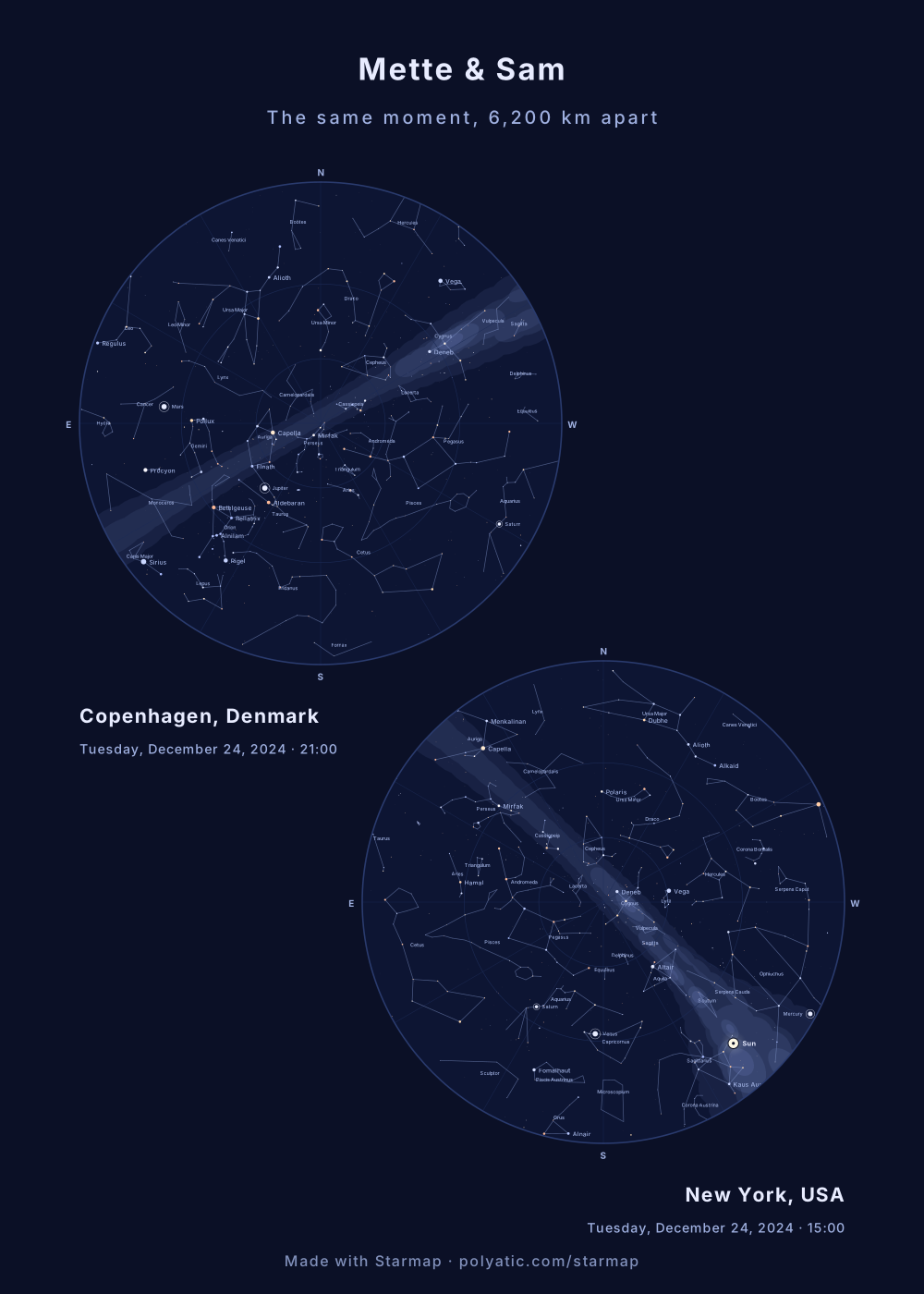
For people who live apart: one poster with two equal sky discs, one for each city, under one shared title. Pick Same moment and the generator works out what the clock read in the second city; pick A different night and each sky keeps its own date.
Make a two-sky poster
Free, no account, nothing to buy. Opens Two skies on Same moment; type both towns there.
Here is the true part most star-map gifts gloss over: two people far apart are not under the same stars at the same instant. The Earth curves between you, so each city has a different patch of sky overhead. In the example above, Capella stands 67° up over Copenhagen but only 12° above New York's north-eastern horizon, while Deneb, 33° up in Copenhagen, is almost straight overhead in New York (82°). And at that instant it was still afternoon in New York: the Sun was 13° up in the south-west, so that disc shows a daytime sky. The stars are drawn where they stood, and the words under the chart say that daylight hid them. A two-sky poster shows all of that honestly, which makes it a better keepsake than a slogan.
Building the poster
- Set the first sky as usual. Type the first town, then the date and the local time there. Its UTC offset comes from the town's time zone, summer time included.
- Choose Two skies, then the second sky. Under Layout, pick Two skies and type the second town. Same moment, another place converts the first sky's instant to the second town's own clock and prints that time under its disc; a line in the form says what it worked out, with the zone and whether it was summer or standard time there. A different night asks for the second sky's own date and time instead, for two evenings that each mattered, say the night each of you left (the memorial page shows one).
- One title, two captions, one dedication. Each disc carries its own place and date line; the title and subtitle are shared and sit above both. Edit the second place label if you want a street or a nickname instead of the town name. Under More text, a dedication of up to three lines of 60 characters is set centred under both skies (“Copenhagen to New York, 6,200 km, every night since June”); both discs are taken in a little to make the room, about 5 % of their width for three lines on A4, never below 60 % of their size.
- Every size works. Paper sizes and phone wallpapers stack the two skies, desktop wallpapers and the square post put them side by side. Both discs are always the same size. Stacked on one sheet they are smaller than a one-sky poster's disc: about 51–52 % of the width on A4 and 50 × 70 cm, against 86–88 % for one sky.
Try it: Copenhagen and New York at the same moment
Good occasions for this: a couple in different cities, a parent and a child who moved away, friends split across a move, or the moment you last spoke. If you would rather hang two matching frames, leave the layout on One sky and make one map per city with the same theme and size; Two skies with Same moment will still tell you the second city's local time to type in.
What the chart draws
The chart holds the 1,630 stars brighter than magnitude 5.0 and the 89 constellation figures, and the Milky Way is drawn as a soft band. The Moon is drawn in its real phase, and left off when it was below your horizon. The five naked-eye planets, Mercury, Venus, Mars, Jupiter and Saturn, are drawn where they stood. The Sun is drawn too whenever it was up, and the caption says whether your moment was daylight, twilight or full dark: the stars are always drawn where they stood, even when daylight or twilight hid them. So is an eclipse, if your moment falls inside one. Uranus, Neptune and 133 deep-sky objects are one switch away: tick Deep-sky objects and the chart marks the Messier objects and southern showpieces and adds Uranus and Neptune (see them over London on a winter evening). Great comets since 1900 can be added (Hale-Bopp over London, 1997). Not drawn: faint comets and satellites, whose orbits this tool does not compute. Every position is carried to your date by precession. Not modelled: the stars’ own proper motion. A date before 15 October 1582 is read in the Julian calendar. It all runs in your browser, nothing is uploaded, and the downloads are complete and free. Accuracy, print sizes and privacy, answered in full.
Common questions
Are we really under the same sky when we're far apart?
Not exactly, and the pair is more honest and more interesting than the slogan. At the same instant, two distant cities have different stars overhead — the Earth curves between you. What you truly share is bright stars low on the horizon toward each other, and the same date. The two charts show that difference plainly.
Same moment or two different nights?
Same moment shows one instant from both places: you enter the date and time where the first sky is, and the generator works out the second city's local time from its own time zone, summer time included, and prints it under that sky (21:00 on 24 December 2024 in Copenhagen is 15:00 in New York). A different night gives the second sky its own date and time, for two evenings that each mattered.
Can I still make two separate prints for two frames?
Yes. Leave the layout on One sky and make one map per city with the same theme and size. Use Two skies with Same moment once to read off the second city's local time, then enter that time for the second print.